Contents
- Create netCDF-CF of a timeseries
- Define meta-info: global
- Define dimensions/coordinates
- Define variable (define some data)
- 1.a Create netCDF file
- 1.b Add overall meta info
- 2 Create matrix span dimensions
- 3.a Create coordinate variables: time
- 3.b Create coordinate variables: longitude
- 3.c Create coordinate variables: latitude
- 3.d Create coordinate variables: coordinate system: WGS84 default
- 3.e Station number/name/code: proposed on:
- 4 Create dependent variable
- 5.a Create all variables with attributes
- 5.b Fill all variables
- 6 Check file summary
- 7.a Load the data: using the variable names from nc_dump
- 7.b Load the data: using standard_names and coordinate attribute
- 7.c Load the data: using a dedicated function developed for grids
Create netCDF-CF of a timeseries
example of how to make a netCDF file with CF conventions of a
variable that is a timeseries. In this special case
the main dimension coincides with the time axis.
This case is described in:
* http://cf-pcmdi.llnl.gov/documents/cf-conventions/1.4/cf-conventions.html#id2984788 (simple)
* https://cf-pcmdi.llnl.gov/trac/wiki/PointObservationConventions (full definition)
%See also: SNCTOOLS, NC_CF_STATIONTIMESERIES,...
%          NC_CF_GRID_WRITE_LAT_LON_ORTHOGONAL_TUTORIAL,
%          NC_CF_GRID_WRITE_LAT_LON_CURVILINEAR_TUTORIAL,
%          NC_CF_GRID_WRITE_X_Y_ORTHOGONAL_TUTORIAL
%          NC_CF_GRID_WRITE_X_Y_CURVILINEAR_TUTORIAL

% This tool is part of <a href="http://www.OpenEarth.eu">OpenEarthTools</a> under the <a href="http://www.gnu.org/licenses/gpl.html">GPL</a> license.
Define meta-info: global
   OPT.title                  = '';
OPT.institution            = '';
OPT.source                 = '';
OPT.history                = ['tranformation to netCDF: $HeadURL: https://repos.deltares.nl/repos/OpenEarthTools/trunk/matlab/io/netcdf/nctools/nc_cf_stationTimeSeries_write_tutorial.m $'];
OPT.references             = '';
OPT.email                  = '';
OPT.comment                = '';
OPT.version                = '';
OPT.acknowledge            =['These data can be used freely for research purposes provided that the following source is acknowledged: ',OPT.institution];
OPT.disclaimer             = 'This data is made available in the hope that it will be useful, but WITHOUT ANY WARRANTY; without even the implied warranty of MERCHANTABILITY or FITNESS FOR A PARTICULAR PURPOSE.';
Define dimensions/coordinates
   OPT.lon                    = 4.908893108;
OPT.lat                    = 52.37952805;
OPT.station_name           = 'Hoek van Holland';
OPT.wgs84.code             = 4326;
Define variable (define some data)
   OPT.val                    = [1 2 3 nan 5 6];
OPT.datenum                = datenum(2001:2006,1,1);
OPT.timezone               = '+01:00';  % MET=+1
OPT.varname                = 'windspeed';   % free to choose: will appear in netCDF tree
OPT.units                  = 'm/s';         % from UDunits package: http://www.unidata.ucar.edu/software/udunits/
OPT.long_name              = 'wind speed '; % free to choose: will appear in plots
OPT.standard_name          = 'wind_speed';
OPT.val_type               = 'single';      % 'single' or 'double'
OPT.fillvalue              = nan;
1.a Create netCDF file
   ncfile = fullfile(fileparts(mfilename('fullpath')),[mfilename,'.nc']);

nc_create_empty (ncfile)
1.b Add overall meta info
http://cf-pcmdi.llnl.gov/documents/cf-conventions/1.4/cf-conventions.html#description-of-file-contents
   nc_attput(ncfile, nc_global, 'title'         , OPT.title);
nc_attput(ncfile, nc_global, 'institution'   , OPT.institution);
nc_attput(ncfile, nc_global, 'source'        , OPT.source);
nc_attput(ncfile, nc_global, 'history'       , OPT.history);
nc_attput(ncfile, nc_global, 'references'    , OPT.references);
nc_attput(ncfile, nc_global, 'email'         , OPT.email);

nc_attput(ncfile, nc_global, 'comment'       , OPT.comment);
nc_attput(ncfile, nc_global, 'version'       , OPT.version);

nc_attput(ncfile, nc_global, 'Conventions'   , 'CF-1.4');
nc_attput(ncfile, nc_global, 'CF:featureType', 'Grid');  % https://cf-pcmdi.llnl.gov/trac/wiki/PointObservationConventions

nc_attput(ncfile, nc_global, 'terms_for_use' , OPT.acknowledge);
nc_attput(ncfile, nc_global, 'disclaimer'    , OPT.disclaimer);
2 Create matrix span dimensions
http://cf-pcmdi.llnl.gov/documents/cf-conventions/1.4/cf-conventions.html#dimensions
   nc_add_dimension(ncfile, 'time'    , length(OPT.datenum));
nc_add_dimension(ncfile, 'string'  , length(OPT.station_name)); % you could set this to UNLIMITED, be we suggest to keep UNLIMITED for time

% If you would like to include more locations of the same data,
% you can optionally use 'location' as a 2nd dimension.
% Here we use it for one station too, to be able to link cordinates.

nc_add_dimension(ncfile, 'location', 1);
3.a Create coordinate variables: time
http://cf-pcmdi.llnl.gov/documents/cf-conventions/1.4/cf-conventions.html#time-coordinate
   % For time we use "x units since reference_date + timezone", where
% * x              can be a character or number,
% * units          can be any units from UDunits: e.g. days, seconds, years, ...
% * reference_date is the moment where t-0 is defined in ISO notation
% * timezone       offset from GMT, in format -/+  HH:00
% For reference_date we advice to use a common epoch. Although gthis is a
% matlab tutorial, the matlab datenumber convention is not adviced:
% Here a a serial date number of 1 corresponds to Jan-1-0000. However, this
% epoch gives wrong dates in ncbrowse, as it uses a different calender. The
% Excel epoch of 31-dec-1899 is too stupid to be worth  mentioning. The Apple
% convenction of 1980 has been superseded since Apple uses unix as a basis. So
% * 1970-01-01    is adviced to use as epoch, the very common linux datenumber
%                 convention (which has no calender issues).

OPT.refdatenum             = datenum(1970,1,1);

clear nc;ifld = 1;
nc(ifld).Name             = 'time';   % dimension 'time' is here filled with variable 'time'
nc(ifld).Nctype           = 'double'; % time should always be in doubles
nc(ifld).Dimension        = {'time'};
nc(ifld).Attribute(    1) = struct('Name', 'long_name'      ,'Value', 'time');
nc(ifld).Attribute(end+1) = struct('Name', 'units'          ,'Value', ['days since ',datestr(OPT.refdatenum,'yyyy-mm-dd'),' 00:00:00 ',OPT.timezone]);
nc(ifld).Attribute(end+1) = struct('Name', 'standard_name'  ,'Value', 'time');
nc(ifld).Attribute(end+1) = struct('Name', 'actual_range'   ,'Value', [min(OPT.datenum(:)) max(OPT.datenum(:))]-OPT.refdatenum);
3.b Create coordinate variables: longitude
http://cf-pcmdi.llnl.gov/documents/cf-conventions/1.4/cf-conventions.html#longitude-coordinate
   ifld = ifld + 1;
nc(ifld).Name             = 'lon';
nc(ifld).Nctype           = 'double';
nc(ifld).Dimension        = {'location'};
nc(ifld).Attribute(    1) = struct('Name', 'long_name'      ,'Value', 'longitude');
nc(ifld).Attribute(end+1) = struct('Name', 'units'          ,'Value', 'degrees_east');
nc(ifld).Attribute(end+1) = struct('Name', 'standard_name'  ,'Value', 'longitude');
nc(ifld).Attribute(end+1) = struct('Name', 'actual_range'   ,'Value', [min(OPT.lon(:)) max(OPT.lon(:))]);
nc(ifld).Attribute(end+1) = struct('Name', 'coordinates'    ,'Value', 'lat lon');
nc(ifld).Attribute(end+1) = struct('Name', 'grid_mapping'   ,'Value', 'wgs84');
3.c Create coordinate variables: latitude
http://cf-pcmdi.llnl.gov/documents/cf-conventions/1.4/cf-conventions.html#latitude-coordinate
   ifld = ifld + 1;
nc(ifld).Name             = 'lat';
nc(ifld).Nctype           = 'double';
nc(ifld).Dimension        = {'location'};
nc(ifld).Attribute(    1) = struct('Name', 'long_name'      ,'Value', 'latitude');
nc(ifld).Attribute(end+1) = struct('Name', 'units'          ,'Value', 'degrees_north');
nc(ifld).Attribute(end+1) = struct('Name', 'standard_name'  ,'Value', 'latitude');
nc(ifld).Attribute(end+1) = struct('Name', 'actual_range'   ,'Value', [min(OPT.lat(:)) max(OPT.lat(:))]);
nc(ifld).Attribute(end+1) = struct('Name', 'coordinates'    ,'Value', 'lat lon');
nc(ifld).Attribute(end+1) = struct('Name', 'grid_mapping'   ,'Value', 'wgs84');
3.d Create coordinate variables: coordinate system: WGS84 default
    global ellispes: WGS 84, ED 50, INT 1924, ETRS 89 and the upcoming ETRS update etc.
http://cf-pcmdi.llnl.gov/documents/cf-conventions/1.4/cf-conventions.html#grid-mappings-and-projections
http://cf-pcmdi.llnl.gov/documents/cf-conventions/1.4/cf-conventions.html#appendix-grid-mappings
   ifld = ifld + 1;
nc(ifld).Name         = 'wgs84'; % preferred
nc(ifld).Nctype       = nc_int;
nc(ifld).Dimension    = {};
nc(ifld).Attribute    = nc_cf_grid_mapping(OPT.wgs84.code);
var2evalstr(nc(ifld).Attribute)
ans =

variable1(1).Name = 'name';
variable1(1).Value = 'WGS 84';
variable1(2).Name = 'epsg';
variable1(2).Value = 4326;
variable1(3).Name = 'grid_mapping_name';
variable1(3).Value = 'latitude_longitude';
variable1(4).Name = 'semi_major_axis';
variable1(4).Value = 6378137;
variable1(5).Name = 'semi_minor_axis';
variable1(5).Value = 6356752.3142;
variable1(6).Name = 'inverse_flattening';
variable1(6).Value = 298.2572;
...
3.e Station number/name/code: proposed on:
https://cf-pcmdi.llnl.gov/trac/wiki/PointObservationConventions
        ifld = ifld + 1;
nc(ifld).Name         = 'station_id';
nc(ifld).Nctype       = 'char';
nc(ifld).Dimension    = {'location','string'};
nc(ifld).Attribute(1) = struct('Name', 'long_name'      ,'Value', 'station identification code');
nc(ifld).Attribute(2) = struct('Name', 'standard_name'  ,'Value', 'station_id'); % standard name
4 Create dependent variable
    http://cf-pcmdi.llnl.gov/documents/cf-conventions/1.4/cf-conventions.html#variables
Parameters with standard names:
http://cf-pcmdi.llnl.gov/documents/cf-standard-names/standard-name-table/current/
   ifld = ifld + 1;
nc(ifld).Name             = OPT.varname;
nc(ifld).Nctype           = nc_type(OPT.val_type);
nc(ifld).Dimension        = {'location','time'};
nc(ifld).Attribute(    1) = struct('Name', 'long_name'      ,'Value', OPT.long_name    );
nc(ifld).Attribute(end+1) = struct('Name', 'units'          ,'Value', OPT.units        );
nc(ifld).Attribute(end+1) = struct('Name', '_FillValue'     ,'Value', OPT.fillvalue    );
nc(ifld).Attribute(end+1) = struct('Name', 'actual_range'   ,'Value', [min(OPT.val(:)) max(OPT.val(:))]);
nc(ifld).Attribute(end+1) = struct('Name', 'coordinates'    ,'Value', 'lat lon');
nc(ifld).Attribute(end+1) = struct('Name', 'grid_mapping'   ,'Value', 'epsg');
nc(ifld).Attribute(end+1) = struct('Name', 'standard_name'  ,'Value', OPT.standard_name);
5.a Create all variables with attributes
   for ifld=1:length(nc)
nc_addvar(ncfile, nc(ifld));
end
5.b Fill all variables
   nc_varput(ncfile, 'time'         , OPT.datenum - OPT.refdatenum);
nc_varput(ncfile, 'lon'          , OPT.lon         );
nc_varput(ncfile, 'lat'          , OPT.lat         );
nc_varput(ncfile, 'wgs84'        , OPT.wgs84.code  );
nc_varput(ncfile, 'station_id'   , OPT.station_name);
nc_varput(ncfile, OPT.varname    , OPT.val         );
6 Check file summary
   nc_dump(ncfile);
fid = fopen(fullfile(fileparts(mfilename('fullpath')),[mfilename,'.cdl']),'w');
nc_dump(ncfile,fid);
fclose(fid)
netCDF F:\checkouts\OpenEarthTools\matlab\io\netcdf\nctools\nc_cf_stationTimeSeries_write_tutorial.nc {

dimensions:
time = 6 ;
string = 16 ;
location = 1 ;


variables:
// Preference 'PRESERVE_FVD':  false,
// dimensions consistent with ncBrowse, not with native MATLAB netcdf package.
double time(time), shape = [6]
time:long_name = "time"
time:units = "days since 1970-01-01 00:00:00 +01:00"
time:standard_name = "time"
...
7.a Load the data: using the variable names from nc_dump
   Da.datenum = nc_varget(ncfile,'time') + datenum(1970,1,1);
Da.var     = nc_varget(ncfile,'windspeed')
Da =

dep: [3x5 double]
lat: [3x1 single]
lon: [5x1 single]
datenum: [6x1 double]
var: [1 2 3 NaN 5 6]
7.b Load the data: using standard_names and coordinate attribute
   Db.datenum = nc_cf_time(ncfile);

varname    = nc_varfind(ncfile,'attributename', 'standard_name', 'attributevalue', 'wind_speed')
Db.var     = nc_varget(ncfile,OPT.varname);
varname =

windspeed
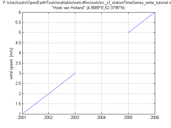
7.c Load the data: using a dedicated function developed for grids
[Dc,Mc] = nc_cf_stationTimeSeries(ncfile,OPT.varname,'plot',1);