Extract data from netCDF database
extract lat, lon, z, data from the netCDF database. See the read JarKus tutorial if this is new to you.
url         = jarkus_url;
id          = nc_varget(url,'id');
transect_nr = find(id==8007000)-1;
year        = 1970 + floor(nc_varget(url,'time')/365);
year_nr     = find(year == 1993)-1;
lat         = nc_varget(url,'lat',[transect_nr,0],[1,-1]);
lon         = nc_varget(url,'lon',[transect_nr,0],[1,-1]);
z           = nc_varget(url,'altitude',[year_nr,transect_nr,0],[1,1,-1]);
Error using netcdflib
The NetCDF library encountered an error during execution of 'open' function - 'I/O failure (NC_EIO)'. If the data source was an  OPeNDAP URL, see the OPeNDAP Troubleshooting section in the Users Guide.

Error in netcdf.open (line 60)
        [varargout{:}] = netcdflib ( 'open', filename, varargin{1} );

Error in nc_varget_tmw>varget_nc (line 21)
ncid=netcdf.open(ncfile,'NOWRITE');

Error in nc_varget_tmw (line 5)
    [data,info] = varget_nc(ncfile,varname,varargin{:});

Error in nc_vargetr (line 38)
   		[data,info] = nc_varget_tmw(ncfile,varname,varargin{:});

...
Check the data
we will check the data with matlab line:
line(lat,lon,z)
view([-67 32])
grid on
Since there are NaN values in the data, not al datapoints are connected.
line(lat,lon,z,'lineStyle','none','marker','.','color',[1 0 0])
We can overcome this problem by linear interpolation of z to xRSP.
xRSP        = nc_varget(url,'cross_shore');
not_nan     = ~isnan(z);
zi          = interp1(xRSP(not_nan),z(not_nan),xRSP);
we will check the data again with matlab line:
clf; line(lat,lon,zi)
view([-67 32])
grid on
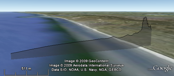
Make line plot
This works as expected, so now we will plot the data. We will exagerate the z data, by adding 20 and multiplying by 5, using the zScaleFun;
fname = 'Jarkus.kml';
KMLline(lat,lon,zi,'fileName',fname,'zScaleFun',@(z)(z+20)*5);
Animation in time
Get altitude for multiple years
z = nc_varget(url,'altitude',[1,transect_nr,0],[-1,1,-1]);
interpolate z
zi = nan(size(z));
for yy = 1:size(z,1)
    not_nan     = ~isnan(z(yy,:));
    zi(yy,:)    = interp1(xRSP(not_nan),z(yy,not_nan),xRSP);
end
We must provide lat and lon data for every entry of z;
lat = repmat(lat,size(z,1),1);
lon = repmat(lon,size(z,1),1);
An we must get the times.
timeIn  = datenum(year,1,1);
timeOut = datenum(year+1,1,1);
KMLline(lat',lon',zi','timeIn',timeIn,'timeOut',timeOut,...
    'fileName',fname,'zScaleFun',@(z)(z+20)*5);
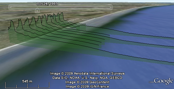
Multiple animated transects
Finally we can also plot multiple jarkus transects at once. We will start from the beginning, with querying the data
no_of_transects = 10;
no_of_years     = 15;
url             = jarkus_url;
id              = nc_varget(url,'id');
start_transect  = find(id==8007000)-1;
year            = 1970 + floor(nc_varget(url,'time')/365);
start_year      = find(year == 1990)-1;
lat             = nc_varget(url,'lat',[start_transect,0],[no_of_transects,-1]);
lon             = nc_varget(url,'lon',[start_transect,0],[no_of_transects,-1]);
z               = nc_varget(url,'altitude',...
                   [start_year,start_transect,0],...
                   [no_of_years,no_of_transects,-1]);
year            = 1970 + floor(nc_varget(url,'time',start_year,no_of_years)/365);
xRSP            = nc_varget(url,'cross_shore');
Interpolation of z, notice the use of squeeze.
zi = nan(size(z));
for yy = 1:no_of_years
    for nn = 1:no_of_transects
        not_nan     = squeeze(~isnan(z(yy,nn,:)));
        zi(yy,nn,:) = interp1(xRSP(not_nan),squeeze(z(yy,nn,not_nan)),xRSP);
    end
end
KMLline can not handle 3D inputs, so wil will have to put all the data in a 2D matrix. This requires some careful reshaping, to make sure the right lat/lon, z and time information are matched.
- First step is expanding lat and lon to the same size as z
lat2 = nan(size(z));
lon2 = nan(size(z));
for yy = 1:no_of_years
    lat2(yy,:,:) =  lat;
    lon2(yy,:,:) =  lon;
end
- Then we reshape the data to a 2D matrix
lat2    = reshape(lat2,no_of_years*no_of_transects,[]);
lon2    = reshape(lon2,no_of_years*no_of_transects,[]);
zi      = reshape(zi  ,no_of_years*no_of_transects,[]);
- Time data also has to be reshaped
year    = repmat(year,no_of_transects,1)';
timeIn  = datenum(year,1,1);
timeOut = datenum(year+1,1,1);
- And finally we can call KMLline
KMLline(lat2',lon2',zi','timeIn',timeIn,'timeOut',timeOut,...
        'zScaleFun',@(z) (z+20)*5,'fileName',fname);